About Caledon
Overview
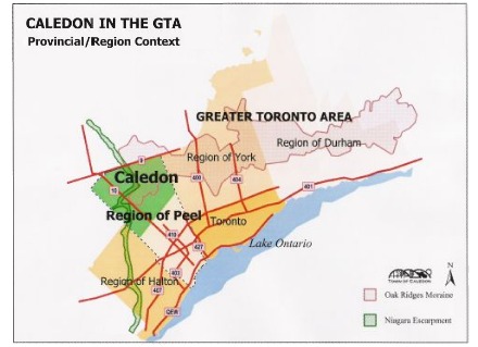
 Caledon is a town in Peel Region which is just north of Toronto Ontario, Canada. Caledon’s population is approx. 57,050(2006) and is growing slowly as development creeps further north. In terms of land use Caledon is primarily rural in nature, however it does border the urban centers of Brampton and Orangeville. Caledon consists of an amalgamation of a number of urban areas, villages, and hamlets; its major urban centre with typified suburban housing mixed with old town charm is Bolton. Many of Toronto’s wealthiest citizens own large country estates in the area, among them many members of the Eaton Family, Norman Jewison, Elton John and the inventors of the board game Trivial Pursuit. Maclean’s magazine has named Caledon as the safest town in Canada to live in.
The primary administrative and commercial centre of Caledon is the town of Bolton, which the municipal government estimated as having a population of 26,478 in 2006. Smaller communities in the town include Albion, Alloa, Alton, Belfountain, Boston Mills, Brimstone, Caledon, Caledon East, Campbells Cross, Castlederg, Cataract, Cedar Meadows, Cedar Mills, Cheltenham, Claude, Coulterville, Ferndale, Forks of the Credit, The Grange, Humber, Humber Grove, Inglewood, Kilmanagh, Lockton, Mayfield West, Macville, Melville, McLeodville, Mono Mills, Mono Road, New Glasgow, Palgrave, Queensgate, Rockside, Rosehill, Sandhill, Silver Creek, Sleswick, Sligo, Snelgrove, Stonehart, Taylorwoods, Terra Cotta, Tormore, Valleywood and Victoria.
History

The Town of Caledon was established on January 1, 1974 in conjunction with the creation of regional government. Representing an amalgamation of the former County of Peel townships of Albion, Caledon and the northern half of Chinguacousy, the Town of Caledon forms the northern municipality of the present Region of Peel. The name ‘Caledon’ was chosen through public referendum in 1973; the other choices on the ballot were ‘Albion’ and ‘Cardwell’, the latter being an historic electoral district from 1867-1908 that encompassed the Town of Orangeville and four neighbouring townships.
The County of Peel was created in 1805 following the purchase by the British Crown of the southern part of the Mississauga Tract on the shore of Lake Ontario. The former townships of Albion, Caledon and Chinguacousy were established as part of the ‘New Survey’ of the County of Peel, which greatly extended the northern boundary of the county following purchase of the remainder of the Mississauga Tract in 1818. The lot and concession grid pattern of the ‘New Survey’ was distinct from that of the ‘Old Survey’, with a different orientation of concessions and lot dimensions. The 200 acre lots of the ‘New Survey’ were typically granted in square 100 acre parcels, a configuration intended to facilitate farming and access to transportation corridors.
Surveyed in 1818-1819, the townships of Albion, Caledon and Chinguacousy were opened for settlement in 1820. Albion Township comprised eleven concessions laid out west to east. In Caledon and Chinguacousy townships, six concessions were laid out on either side of Hurontario Street, also known as Centre Road (and currently known as Provincial Highway 10). As this centre baseline duplicated the numbering of the concessions, concessions in these two townships were further denoted by ‘West of Hurontario Street’ (WHS) or ‘East of Hurontario Street’ (EHS).
Early settlements in the townships developed around water-powered mill sites on the Credit and Humber rivers, and at various crossroads. The arrival of the Toronto Grey & Bruce, Hamilton & Northwestern and Credit Valley railways in the 1870s spurred further settlements at various junctions. Development was also influenced by the area’s major landforms, including the Peel Plain, the Niagara Escarpment and the Oak Ridges Moraine. While some historic hamlets have disappeared over time, Caledon’s present-day communities continue to reflect early settlement patterns.
Trials and Protected Areas
The Town of Caledon has over 70 parks totalling more than 300 acres. There is also over 260 km of publicly accessible trails within the Town of Caledon including 105 km of the Bruce Trail. The Town of Caledon currently owns and maintains the 36 km of the Caledon Trailway, and a 1 km portion of the Etobicoke Creek Trail.
- Bruce Trail
- Caledon Trailway
- Elora-Cataract Trail
- Grand Valley Trail
- Humber Valley Trail
- Andrews Treasuretrail
- Oak Ridges Trail
- Albion Hills Conservation Area
- Alton Forest Conservation Area
- Belfountain Conservation Area
- Caledon Lake Forest Conservation Area
- Forks of the Credit Provincial Park
- Glen Haffy Conservation Area
- Heart Lake Conservation Area
- Ken Whillans Conservation Area
- Palgrave Conservation Area
- Robert Baker Forest Conservation Area
- Terra Cotta Forest Conservation Area
- Warwick Conservation Area
